


Quick Facts About Algeria
Official name: People’s Democratic Republic of Algeria
Capital city: Algiers
Location: North Africa
Neighbors: Libya (East). Tunisia (North-east), Morocco (North-west), Mali (South-west), Niger (South-east), Mauritania (West), Mediterranean Sea (North).
Official language: Arabic
Other languages spoken: French, Algerian Arabic (Darja)
Major ethnic group: Arab-Berber (99%)
Main Religion: Islam
Independence: 3 July 1962 (from France)
Current constitution: 10 September 1963
Area: 2,381,741sq. km
Population: 42,200,000 (2018 estimates)
GDP: $693.109billion (2019 estimates)
GDP Per Capita: $16,085 (2019 estimates)
Currency: Dinar (DZD)
Time zone: UTC+1 (CET)
Driving side: Right
Calling code: +213
Tourism in Algeria is gaining momentum due to recent peace and security and strategic tourism development campaign ‘Horizon 2025’ that was created in 2008 to improve human resource and infrastructure including accommodations, transport, and attractions. Algeria has created safe tourism zones, improved its international relations and tourist visa policy making the country safe to visit for everyone including for female travelers.
Among the safe corridors include 5 UNESCO world heritage sites of Tipasa, Timgad, Casbah of Algiers, Djemila and Beni Hammad Fort; 8 protected areas including Tlemcen, El Kala, Belezma, Taza, Chrea, Djurdjura, Gouraya, and Theniet El Had national parks and mount Tahat which is part of the Great Atlas Mountain Range; 8 national museums of art and archaeological importance and 6 mosques of which Djamaa el Djazaïr is the third-largest mosque in the world. According to CNN Algeria received 3.5 million visitors in 2023 of which 2.2 million were foreigners indicating that travel is gaining momentum.
Algeria guided tours are available for booking through a genuine tour operator. As one of the emerging travel destinations in the Mediterranean region Algeria offers a rich blend of history, culture and adventure. Some of the beautiful places in Algeria include the Great Kabylie Mountains, Tikjda, Constantine the city of Bridges, Ghardaia, and M’Zab Valley in the Sahara desert. The Mediterranean warm climate is pleasant and the best time to visit is in autumn from April to May and Spring season in September to November. According to World Atlas, Algeria has a wide range of natural resources including rich mineral deposits of gold, lead, zinc, helium, silicon, iron of which natural gas at 2.2 billion cubic feet and oil estimated at 12.2 billion barrels of oil reserves is the major foreign exchange earner. Algeria is a middle income country with a Growth Domestic Product of $247.63 billion (Source: World Bank Open Data 2023).
 People and culture
Algeria has a population of 46.3 million people (Source: UNFPA 2024) of which Arabs constitute over 75% and many have ancestry that is associated with the indigenous Berbers. Among other ethnic groups in the country include Mozabites, Kabyle, Chaoui, Chenoua, Tuareg, Jews and Europeans. The Tuareg people are semi-nomadic Barbers famous for their distinct blue cultural attire which includes turbans and robes. Those intending to visit them can go to Ahaggar national park where the tomb of Tin Hinan, Queen of the Tuareg is found and the historical landmark at Tabalesa. Tuaregs are also known for spreading Islam across North Africa given that they are among the indigenous groups in many countries including Burkina Faso, Mali, and Niger.
Arabic is the official language spoken by over 81% of the people and the main region is Sunni Islam due to the historical Arab-Muslim conquest of the 7th century that influenced many indigenous groups in Algeria and North Africa at large. As such, the daily life and social norms Algerians is mainly influenced by Islamic values along with a relative influences of Mediterranean, Christianity, and French. Algerians have preserved their local customs including indigenous languages such as Tamazight which is the second official language. French and English are also spoken especially among the younger generations.
Food
Traditional Algerian dishes are also well preserved including the Chakchouka which is mostly prepared as breakfast with ingredients such as sautéed onions, tomatoes, spices topped with eggs. Chakchouka can be enjoyed along with bread and rice. Algerians enjoy soups for lunch including Hariri soup a light and filling local dish that is made with vegetables, herbs, spices, and lamp cooked in earthen pot and served with fresh bread and salads. Soups are enjoyed with a wide range of dishes including the Couscous that is considered to be the national dish of Algeria. Couscous is locally known as Kousksi or Seksou among the Berbers. In Algeria the dish is prepared with semolina a yellow colored flour obtained from durum wheat. Semolina is mixed with boiling water or broth and rolled into pallets making for one of the easiest dishes to cook. In addition to the traditional dishes, Algeria offers a wide range of continental dishes given her location in the Mediterranean region and close to Europe.
Music
The traditional music, dance and drama of Algeria known as Raï. Origins of Rai music are associated with the generation of 1920s due to cultural shifts towards new forms of expression. Rai started as folklore in the city of Oran, the “sLittle Paris” and gained momentum with various artists including Bellamou Messaoud, Cheikha Rimitti, Belkacem Bouteldja, Cheikh Hamada, Cheb Khaled who used a combination of traditional and modern instruments and styles to make it more appealing globally. According to UNESCO, Rai has been used a means of conveying social reality without taboos or censorship. Raï music touches on topics such as love, freedom, despair and social pressures and was inscribed on the intangible cultural heritage of humanity in 2022.
Things to see and do
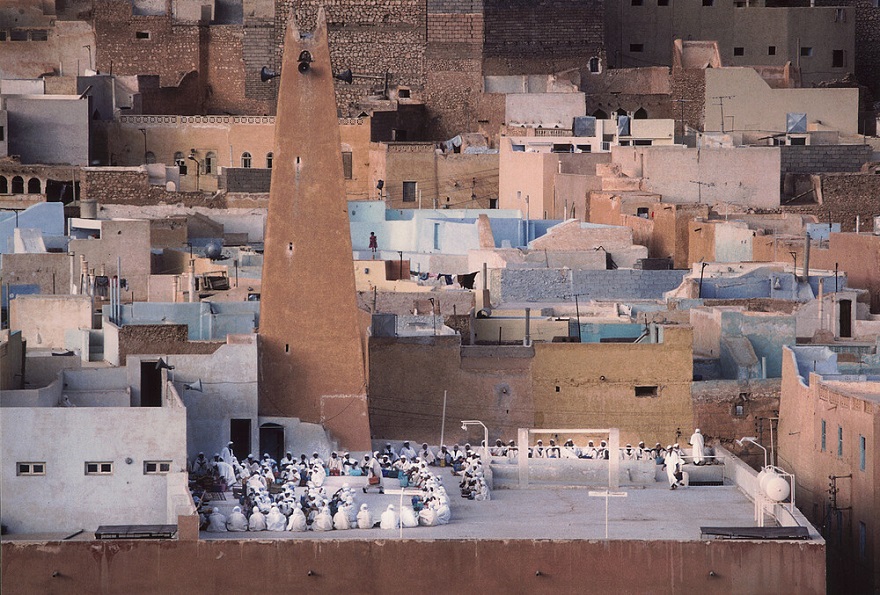
M’Zab Valley in the Sahara Desert is 600 km (8-hour drive) south of Algiers capital city. The valley contains five traditional towns which include Bounoura, Ghardaïa, Melika, El-Atteuf, and Beni-Isguen that were built by Ibadite Berbers between 1,012 and 1,350 during the 12th year of the second millennia. The buildings have stood the test of time since the 11th century and were inscribed on the UNESCO World Heritage List as a unique cultural landscape of Algeria.
The Roman Ruins in Tipasa
Tipasa capital city of Tipasa Province is 65 km (1-hour drive) west of Algiers capital city along the coast of the Mediterranean Sea. The city is famous for harboring ruins that are associated with ancient civilizations of Carthaginians, Romans, and Phoenicians. As such, Tipasa became an important trading port between North Africa and Iberian Peninsula in south west Europe. The ruins contain complex structures under the Tipasa Archeological Park including necropolises, forums, curias, thermal baths, theatres, cemeteries and basilicas which were inscribed on the UNESCO world heritage list in 1982 due to their archeological importance. One of the most outstanding sites is the Great Royal Mausoleum of Mauritania the final resting place of Juba II king of the kingdom of Mauritania who reigned from 25 BC-23 AD, her Queen Cleopatra Selene among other royal members. Juba II was a prince under the Roman Emperor Augustus of the indigenous Barbers that live across North African countries of Algeria, Morocco, Mauritania, Mali, and Libya.
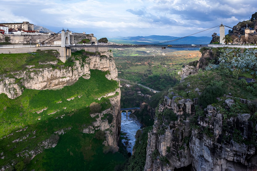 Sidi M’Cid Bridge
Located in Constantine city 387.7 km (4-hour drive) east of Algiers, Sidi M’Cid Bridge is one of the spectacular bridges worth visiting for a keen photographer. There are a series of bridges in the city of which Sidi M’Cid is the longest standing at 575 feet (175 meters) high, making for one of the highest suspension bridges in the world. The bridge was built across the Rhummel River Gorge in 1912 to create road for cars and people can walk on to enjoy the views. The bridge connects Swiqa, the historic Madina of Constantine to the University Hospital Abdelhamid Ben Badis. The best way to experience the bridge is through the Constantine Gondola lift is a gondola lift which it has 33 detachable cabins, each with a seating capacity of 15 people.
National parks
Algeria has 10 national parks including those located along the Mediterranean coast, in the Sahara Desert, and in the mountain and steppe regions.
National parks in the Sahara desert of Algeria
Tassili n’Ajjer national park
The protected area covers 72,000 sq. km along the Tassili n’Ajjer plateau that spans across the borders of south east Algeria, Mali, Libya and Niger. The climate is arid and the area receives relatively little rainfall of 25 mm to 150 mm depending on the time of the year. Temperatures ranges from maximum of 32°C during at and minimum of 2°C at high altitude of the plateau on Mount Afao 2,158 meters above sea level leading to frost and snow during the winter months. The unique physical feature in the area are sedimentary rock formations composed of sandstone, limestone, and shale shaped over millions of years through processes of erosion and sediment deposition to form valleys, arches, pinnacles, and open plains at an altitude range of 1,100 to 1,400 m.a.s.l.
According to NASA Observatory, the rocks are believed to have formed during the Paleozoic Epoch about 300 to 500 million years ago. Tassili River among other rivers flow from the mountain and rain the park creating unique ecosystem of queds, permanent and seasonal gueltas, and hot springs. The Oued Iherir river valley alone contains of over 45 permanent queds, freshwater springs, and marshes around Lake Garaet Ezzemoul. Aquatic plant species found along the gueltas and queds include filamentous green algae, Phragmites australis, and Typha capensis among other tree species that grow in the valleys in Tassili n’Ajjer national park include Acacia nilotica, Phoenix dactylifera, Nerium oleander, Olea laperrinii, Tamarix gallica, and Hyphaene thebaica.
Due to such unique ecosystem, the protected area is rich in biodiversity including 37 mammal species and over 134 bird species of which 14 are endemics including Pharaoh’s eagles, Greater hoopoe-lark, desert lark, Lichtenstein’s sandgrouse, and pale rock martin. Mammals include small cat species such as Saharan sand cats (F. margarita), golden jackal (Canis aureus), Caracal caracal, Felis chaus, fennec foxes; Barbary sheep (Ammotragus lervia), Oryx, and Gundi (Ctenodactylidae) a small African rodent in the family Ctenodactylidae endemic to Northern Africa.
In addition to wildlife, the park is famous for harboring rich archeological heritage including over 15,000 pre-historic rock art images, engravings dating back to 10,000 BC depicting human evolution and wildlife migrations in the Sahara Desert. Tassili n’Ajjer national park was inscribed on the UNESCO world heritage list and as an Important Bird Area in 1982 and 2001 respectively, making for a must-visit gem in Algeria.
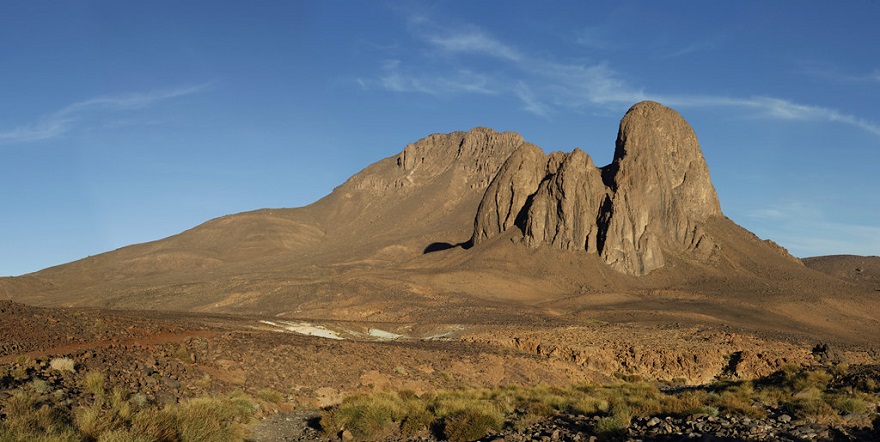 Ahaggar National Park
Ahaggar national park covers 450,000 sq. km in Tamanrasset Province in the central Sahara Desert. The protected area is part of the Hoggar Mountains which extend for 550,000 sq. km in southern Algeria along the Tropic of Cancer. The mountains were formed due to earthquakes and violent volcanic activity that produced basalt lava about 300 million years ago. The nature of igneous rocks are associated with the Pre-Cambrian Epoch making Hoggar one of earth’s oldest mountains. Source: World Geography Encyclopedia. Hoggar Mountains have been shaped by erosion into spectacular jagged formations including spectacular volcanic spires with a height of 300 meters, massive cliffs and fissures, deep ravines, gueltas, and queds which contain permanent oases.
The major peaks in Hoggar mountains in Ahagger national park include Mount Atakor, Mount Assekrem and Mount Tahat. Mount Tahat 2,918 m (9,573 feet) is the tallest mountain in Algeria and is located within Ahaggar national park. Oases in the park include Abalessa, Ziza Oasis, and Abalessa and offer good spots for picnics in the park. For instance, Abalessa oasis is associated with the culture of the Toureg people who believe that their founding mother Queen Tin Hinan was buried there. She lived in the 4th century BCE and is credited for organizing the social structure of the Tuareg including establishment of ancient caravan trading routes across the Sahel region. The deep ravines also contain waterfalls such as Tamekrest and Imeleoulaouene which occasionally get snowfall in the winter season between December and February. Despite of the fact the park has an arid climate there’s some vegetation cover in the southwestern part dominated by date palms (Phoenix dactylifera), tamarix tree species, and myrtle (Myrtus communis) an evergreen shrub with small, glossy green leaves and white, star-shaped flowers. Ahaggar national park supports a variety of wildlife species adopted to the desert including the critically endangered Saharan cheetahs, fennec foxes (Vulpes zerda), bighorn sheep, Dorcas gazelles, and spiny rock hyraxes.
National parks of Algeria along the Mediterranean coast
Algeria has four three protected located along the coast of the Mediterranean Sea which include Taza, El Kala and Gouraya national parks.
El Kala National Park
A UNESCO man and biosphere reserve, El Kala national park is located in Al Kala district in El Taref Province north east Algeria along the Mediterranean Sea coast. The protected area was established in 1983 and recognized as a UNESCO Man and Biosphere Reserve in 1990 due to the ecological and cultural significance. The park spans for 76,384 hectares and contains diverse habitats including sand dunes, forests, 6 lakes both fresh and salt water lakes and a complex of wetlands of which 3 are Ramsar sites. There are pristine beaches along the park’s northern 90 km coastline that offer swimming, boat rides, surfing, and snorkeling. Delta swamps along the coast harbor unique flowering plants including species of Juncus and Salicornia. Both natural and plantation forests occur in the park with various tree species such as cork oak (Quercus suber), Portuguese oak (Quercus faginea), silver wattle (Acacia dealbata), white poplar, black poplar (Populus nigra), among other shrubs such as Nerium oleander and Salix pedicellata.
Gouraya National Park
Known as the Jewel of the Algerian Mediterranean coast Gouraya national park covers 20 sq. km with an altitude range of 135-660 meters above sea level. The protected area encompasses rolling hills, cliffs, rivers, lakes, valleys, beaches, and historical forts which offer opportunities for hiking, rock climbing, swimming, and birding, and watching the endangered Barbery macaques. Due to altitude variation the park’s vegetation variation includes dense maquis shrubs with varies species including Pistacia lentiscus, wild olive (Olea oleaster), and rosemary (Salvia rosmarinus). The scrubland is interspersed with patches of pine and oak forests which contain tree species such as Aleppo pine (Pinus halepensis), Holm oak (Quercus ilex), and carob trees (Ceratonia siliqua).
The rocky soils support grass species such as Esparto grass (Stipa tenacissima), thyme, and various wildflowers that flourish in spring including Mediterranean Spurge, Cyclamen, Crown Anemones, and Wild Gladiolus. The Mediterranean vegetation is rich in biodiversity including 30 mammal species including Barbary macaques (Macaca sylvanus), the park’s flagship species and one of the few primates native to North Africa, Algerian hedgehogs, and wild boars. There are 120 species of birds including Bonelli’s and short toed snake eagles, red necked night jar, European turtle dove, alpine swift, and northern gannet. Mediterranean Sea harbors several marine wildlife species such as sperm whales (Physeter macrocephalus), Harbour porpoises (Phocoena phocoena), Short-beaked common dolphins (Delphinus delphis), and Bottlenose dolphins (Tursiops truncatus).
Gouraya national park is 246.9 km (3-hour drive) north east of Algiers and 8 km from Bejaia city. The park can also be reached by air through Abane Ramdane Airport in Bejaia. The Béjaïa city is served by the Béni Mansour–Béjaïa railway which connects several Algerian cities and rural towns including Algiers capital city and Béni Mansour.
Algerian national parks in the Atlas Mountain Range
The Atlas Mountain range extends for 2,5000 sq. km in North Africa through Tunisia, Morocco and Algeria. The Atlas range in Algeria which is divided into two parts including the Tell Atlas and the Saharan Atlas contains 5 protected areas which include Theniet El Had, Djurdjura, Chrea, Elezma, and Tlemcen national parks explained as follows:-
Théniet El Had national park
The protected area is located in Tissemsilt Province 165 km (2-hour drive) south west of Algiers capital city and 3 km from Théniet El Haâd city. Théniet El Had national park is part of the Tell Atlas in northwest Algeria and covers 34.24 sq. km of which three quarters of the park contain Atlas cedar forests dominated by Cedrus atlantica among other several coniferous tree species such as Cork oak, Holm oak (Quercus ilex), Gall oak (Quercus lusitanica), Cade oak (Juniperus oxycedrus). The vegetation in the Théniet El Had national park also includes grass and herbaceous perennial flowering plant species including Atlantic cranesbill (Geranium atlanticum), viola, Alexanders (Smyrnium olusatrum), Chrysanthemum, European Ivy (Hedera helix) support rich biodiversity including 97 birds and 17 mammal species. Among the mammals in the park include Caracal caracal, weasels, genets, porcupines, slender mongoose (Galerella sanguinea). Some of the 83 natural and artificial waterbodies in the park provide home to aquatic species such as Greek tortoise (Testudo graeca), Montpellier snake (Malpolon monspessulanus), and 18 dragonflies and damselflies species.
Djurdjura national park
Covering 182 sq. km Djurdjura national park is named after the Djurdjura mountain which forms part of the Tell Atlas range in northern Algeria. The range is subdivided into relatively smaller ranges including Lalla Khedidja, also known as Tamgut Aâlayen, the highest peak of with an elevation range 2,308 m (7,572 ft). Being close to the Mediterranean, the Djurdjura range gets snow during the winter season from December to February which offers opportunities for winter snow activities which include skiing and snowboarding. In addition to winter activities, the park’s juniper, Atlas cedar and pine forests provide habitat to wildlife species including the Barbery macaques, wild boars, red foxes (Vulpes vulpes), wild cats (Felis silvestris), striped hyenas (Hyaena hyaena), crested porcupine (Hystrix cristata), and Cape hare (Lepus capensis). Among other species include a variety of birds of prey including peregrine falcon, black vultures, long-legged buzzard, booted eagle, golden eagle and kestrels.
Algerian tourist visa
Most foreign visitors need a tourist visa to enter Algeria which can be obtained either through the Algerian embassy in your home country or via a licensed travel agent if no consulate is available locally. Those from visa exempt countries including Malaysia, Libya, and Seychelles Islands may enter without a visa. Diplomatic/service passport holders from Africa among other countries including Mexico, Vietnam, Italy, Germany, France, Hungary, Croatia, Malta, and Hungary may not need a visa to enter. The most important thing is to first verify whether your home country is visa-exempt. To get a visa you must have a passport valid for at least 6 months from the date of entry. Visa on arrival is only granted to those coming into the country through a genuine tour operator. People from non-visa exempt countries must apply for a visa in advance and the requirements to do so include a passport valid for at least six months, two passport size photos, two copies of an application form, proof of itinerary and accommodation reservation from Algeria and payment by bank transfer, travel insurance, and account statement.
How to get there
Algeria can be reached by air through one of the country’s two main international airports which include Houari Boumediene Airport in Algiers capital city and Es-Sénia Airport in Oran city. Air Algérie operates non-stop flights from Algiers to several hubs in North Africa and Europe including Paris, Marseille, Madrid, Tunis, and Cairo. Algiers capital city and Oran can also be reached by ferry from Marseille city in France via the Mediterranean Sea and Alicante city, Spain via the Gulf of Oran.